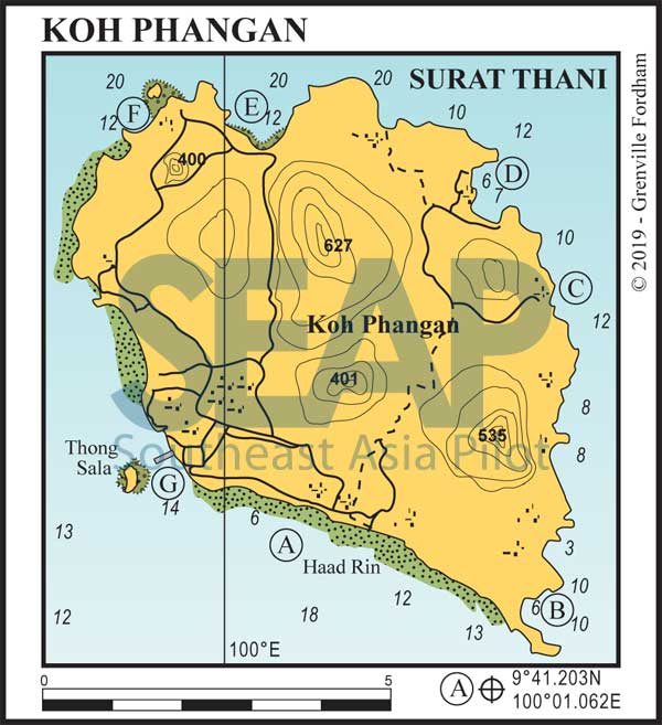
Koh Phangan is famous for its Full Moon parties fills the horizon north of Samui. It now rivals Samui for the number of beach bungalow resorts, but the style is still more rustic with dirt tracks and some paved roads linking some of the beaches.
Read more14 miles from Ao Nathon, Samui


This day anchorage lies in 5-10 metres on the south coast of Koh Phangan. The beach is fringed with coral, and the wind, channelled as it is between the islands, often creates a ground swell. The action in the bars ashore is a big draw for some, but this is really a marginal stopover for a cruising yacht. Great stop for a party crew but only the deaf would be able to sleep here overnight.
5 miles from Haad Rin Nai


The best anchorage is on the northern end of the beach in about 6 metres on a sandy bottom.
There are many restaurants and bungalows ashore. This beach, heir to the Goa and Bali of the late ’60s and early ’70s, has been made famous by ‘full moon parties’ and ‘half moon parties’ attracting thousands of uninhibited revellers every month.
9 miles from Haad Rin Nai


Anchor in 8 metres on a sandy bottom, well offshore in the middle of the bay. This bay is named after Tharn Sadet waterfall, which has a spectacular view of the bay and can be reached by following the creek from the sea. Along the way are engravings commemorating the visits of Kings Rama V, Rama VI and Rama IX.
There are pools big enough to bathe in and a two-inch pipe carries water to the beach, where you can fill your jerry cans for a nominal fee. There are many small restaurants on the beach.
11 miles from Haad Rin Nai


This large double bay boasts two of the best beaches on the island, with fine white sand backed by lush green mountains. The southern bay is the most protected while the northern one can be subject to swell.
Anchor on a sandy bottom in 6-8 metres in front of the big tree on the beach, or in the northen bay in 4 metres on sand. Both bays are quite developed now and the new paved road gives access to the entire Island if you rent a motorbike.
The Panviman Resort has a great infinity edge pool and superb views over the bays from the rocky headland that separates them. A short trek will take you to the Thaanprawet waterfall.
13 miles from Haad Rin Nai


10 miles from haad Rin Nai


Just around the headland to the north is Had Khuat (bottle in Thai), an appealing little bay with resorts ashore. Avoid the charted rock on the eastern side of the bay on approach. Anchor in 6-7 metres nearer to the western side to get the best shelter from westerly swells. Good restaurants ashore.
Further west is Ban Chalok Lam, the island’s second town. Often used by fishing vessels, it has a fermented fish sauce factory – interesting for a short trip if you can handle the stench.
A sealed road goes to the main town, Ban Thong Sala. On the hill above is the Kuan-im shrine, a temple where visitors burn incense sticks; the entrance offers one of the island’s finest views.
Ao Mae Haad has several bungalows and restaurants and is a good swimming and diving location. Anchor in 8-12 metres on sandy bottom.
Just to the south of the western point of Koh Phangan, in a cleared channel through the fringing reef, is a fishing port, 9°45.186N, 99°57.719E. Beware the unmarked drying rock bank 400 metres off the eastern fringe reef.
3 miles from Haad Rin Nai


Anchor in 10 metres east off the small offshore island. This is the island’s principal port and town, as well as being the business and administrative centre.
The bigger passenger vessels arrive here, linking Koh Phangan to Koh Samui and the mainland. The town has retained its character with wooden shophouses and many small restaurants.
