SEAP Southeast Asia Pilot-1
  >   Thailand   >   Pattaya & The Eastern Gulf

Koh Phai

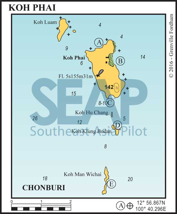
Koh Phai, Koh Klung Budan and Koh Man Wichai chart
  • A

KOH PHAI NORTH

21 miles from South Pattaya Bay

KOH PHAI NORTH. 12°56.867N, 100°40.296E

Anchor well clear of the fringing reef in 4-6 metres on sand, but watch out for, and avoid, the odd coral patch. Pick up a buoy if there is one. This day stop is ideal, in the southwest season, for snorkelling or a walk along the beach.

Click to view Thailand photo gallery.

  • B

KOH PHAI EAST

21 miles from South Pattaya Bay

KOH PHAI EAST. 12°56.429N, 100°40.792E

Anchor opposite the Royal Navy outpost in 5-8 metres. There are some facilities ashore at the Navy buildings, but you should contact an officer before looking around.

Click to view Thailand photo gallery.

  • C

KOH PHAI SOUTH

20 miles from South Pattaya Bay

KOH PHAI SOUTH. 12°55.111N, 100°40.600E

This secluded bay is an ideal day anchorage, offering a fine sandy beach with good snorkelling and clear waters. Anchor in 8-10 metres on sand.

Click to view Thailand photo gallery.

  • D

KOH KLUNG BUDAN

19 miles from South Pattaya Bay

KOH KLUNG BUDAN. 12°54.213N, 100°40.761E

Anchor on sand in 9-12 metres on the northeast end of this island. There is a single rock at the southeast end of the small bay. The water is usually very clear, and the beach is easily accessible by dinghy, offering some of the best snorkelling in this group. Follow the track to a small shrine full of phallic objects on the northern hill.

Click to view Thailand photo gallery.

  • E

KOH MAN WICHAI

18 miles from South Pattaya Bay

KOH MAN WICHAI. 12°52.442N, 100°40.480E

Anchor on sand halfway down the island on the east coast in 5-6 metres. The water is usually clear and good for swimming. Snorkelling is better farther south at Koh Rin. Shelter here is marginal and this is certainly only a daytime anchorage.

Click to view Thailand photo gallery.

See also:

  Go to top

While every effort has been made to ensure that the information contained in this book is accurate, the charts of anchorages are based on personal experience and satellite imagery and are intended as a guide only. They should not be used for navigation. Please refer to Official Hydrographic Charts of the respective countries.

Copyright.
The copyright holders of all content, in print and digital editions, are: Published book © Phuket Publicity Services Ltd. Part. / Texts © Bill O’Leary, Andy Dowden & Grenville Fordham / Design, layout & charts © Grenville Fordham / Photography: © as indicated in photo credits. All rights reserved
No part of this publication may be reproduced, stored, or transmitted in any form or by any means - graphic, electronic or mechanical, including photocopying, recording or otherwise – without the express permission of the publisher, Phuket Publicity Services Limited Partnership, and the other copyright owners.

Phuket Publicity Services Partnership, Ltd.,
Phuket Publicity Services Partnership, Ltd.,19/87 Moo 7,T.Srisunthorn, A. Talang, Phuket 83110 Thailand
Privacy policy