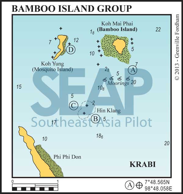
To the north of Phi Phi Don lie two small islands, Koh Mai Phai (‘Bamboo’) and Koh Yung (‘Mosquito’). Between them and the northern tip of Phi Phi Don is a large area of submerged and dangerous coral reef called Hin Klang.
Hin Klang has claimed more captains’ egos than any other submerged rock in the region. This group of reefs and bombies between Koh Mai Pai and north Phi Phi Don is a notorious bare boat and charter cruise holiday spoiler.
The chart plotters are not as accurate as expected, or novice sailors might be ‘cutting it too close’ in their rush around the bay. Hin Klang is several acres wide and littered with hard coral heads rising from 10 metres around its edges. We recommend giving it a very wide berth. Thais have a saying, “Better to lose some time than to lose some face.”

7 miles from Ton Sai Bay, Phi Phi Island


Pick up a mooring or anchor in 7-10 metres on a sandy patch off the southeast corner of the island. Take care making sure to drop your anchor in sand. This avoids damaging the coral and at the same time minimising the chances of fouling your ground tackle.
The small moorings are very close to the reef edge and are only suitable for speedboats and longtails that make the daily snorkelling pilgrimage from Phi Phi. There are Marine Park ranger speedboats collecting a 400 baht per person fee.
A small restaurant may be open during the day. Beware of your course when heading back to Phi Phi. Go well north or south of Hin Klang to avoid the dangerous reef.
6 miles from Ton Sai Bay, Phi Phi Island


The reefs around here are arguably the best diving outside of the Similan Islands. There are no safe overnight anchorages, though some locations can be recommended in either season for lunchtime or diving stopovers. Suitable only in relatively calm weather, never leave your vessel unattended.
8 miles from Ton Sai Bay, Phi Phi Island


Anchor in 9-12 metres on sand outside the fringing reef at the north end of the east coast beach. There may still be one reliable orange mooring south of this spot.
Don’t trust the white moorings in shallower water as they’re thin line fastened to coral heads. Great snorkelling along this reef edge and the entire beach is accessible above a 1.4 metre tide. ‘Yung’ means Mosquito in Thai – and this island is aptly named. Millions of bloodsuckers wait in the shade of the beach overhang. At night they’ll drive you insane.
Click to view Thailand photo gallery.
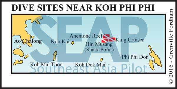
On the passage back to Phuket from Phi Phi islands are some of the best dive sites in the region.
4 miles NNE of Koh Kai is hin Musang, locally known as Shark Point. home to harmless leopard sharks, spectacular soft corals and moray eels, this dive site is one of the most popular. Moorings are placed around this pinnacle rock and can be used on a first-come basis.
Half a mile to the north is anemone Reef, which is marked by a single mooring buoy. Here again magnificent soft purple corals and abundance of fish life.

One mile east of the reef is the wreck of the 85-metre King Cruiser ferry, which came to grief in 1997 after clipping anemone Reef. The wreck is now home to many species of fish and has a colourful coating of corals. This is also marked with a single buoy.
Koh Kai was once famous for schools of sailfish, which unfortunately have ended up in many of the local seafood restaurants. Occasional survivors can be hooked between 4pm and sunset but be sure to catch and release.
None of these open sites afford anchorage overnight.
Shark Point: 7°47.881N, 98°37.651E
King Cruiser: 7°48.143N, 98°38.566E
Anemone Reef: 7°48.462N, 98°37.677E
