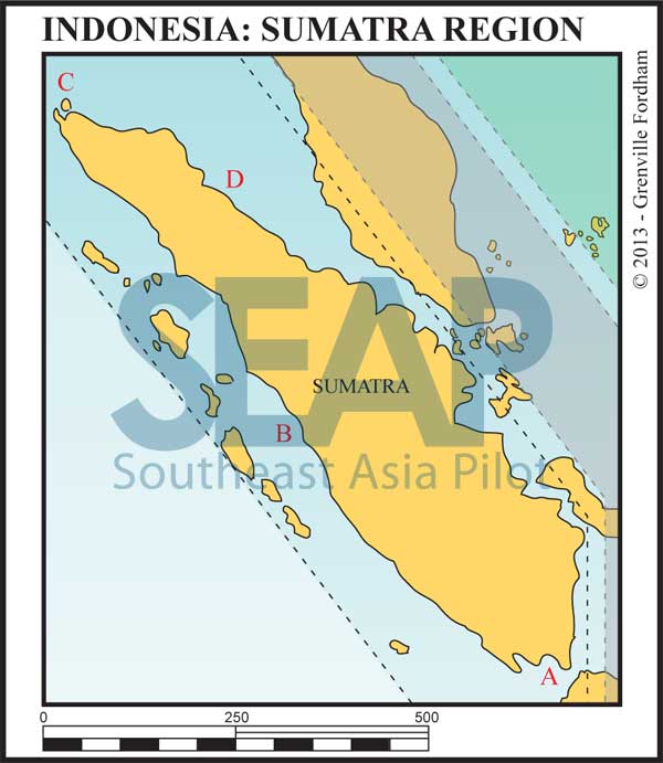
Sumatra is the westernmost of the Sunda Islands and is the largest island entirely Indonesian governed. The larger island, Kalimantan, is shared between Malaysia, Brunei and Indonesia. Sumatra is the world’s sixth largest island with a population of over 50 million. The capital is Medan on the northeastern coast in the Malacca Straits.
Sumatra’s Indian Ocean west coast has the famous surfing island groups of Simeulue, Nias and Mentawai. The northeast coast forms the narrow Malacca Strait with the Malay Peninsular and the southeastern Sunda Strait separates her from Java.
On the lower eastern side are the islands of Bangka and Belitung and the Karimata Strait in the Java Sea. The equator crosses the centre of the island giving the land mass a hot humid climate where tropical rain forests dominate the landscape.
The Great Sumatran fault runs down the entire west coast of the island. On 26 December 2004, the Indo-Australian plate slid under the Eurasian plate causing the devastating Boxing Day tsunami. More than 170,000 Indonesians were killed, primarily in the northeastern Aceh province.
We mention only a few of the many anchorages on offer here and welcome comments, suggestions and notes from cruising yachtsmen for the next edition. Email us at: feedback@southeastasiapilot.com
The famous Sunda Strait stretches in a north-east/south-west orientation, with a minimum width of 16 miles at its north-eastern end between, Cape Tua on Sumatra and Cape Pujat on Java.
It is very deep in the west, getting shallower to the east as it narrows. Cross currents and wind against tide make it sometimes notoriously difficult to navigate.
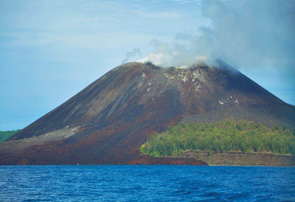
The strait is dotted with a dozen islands, many offering temporary shelter. Half are volcanic in origin, the best known being the famed Krakatoa. In 1883 it exploded killing 36,000 people and destroying most of the island. The blasts are the loudest recorded in modern history, heard some 5,000 kilometres from the origin. Recently the Krakatoa volcano has re-emerged from the ocean and is the principle upward force in the formation of a brand new island, Anak Krakatoa, or ‘Child of Krakatoa’.
An accord was signed in 2012 with the China Railway Construction Corporation to build a road with a double track rail suspension bridge, utilising the islands of Ular, Sangiang and Prajurit. It would have been 70 metres above sea level with a maximum span of three kilometres, making it nearly fifty percent longer than the current world record holder.
However, in November 2014, the incoming government abandoned plans for the bridge, preferring to improve maritime resources such as more passenger and freight vessels and improved port facilities.
The decision to shelve the bridge plans was more than vindicated when, in December 2018, Anak Krakatoa erupted causing a tsunami that killed more than 400, making it the most deadly volcanic eruption this century.
After having lost over two thirds of its volume following the eruption, the volcano has continued evolving. As recently as May 2019, a new crater was observed and the volcano’s volume continues to increase.
Go back to main Sailing & Exploring in Indonesia page
>>> Click here for a complete list of anchorages in Southeast Asia Pilot.
540 miles from Singapore


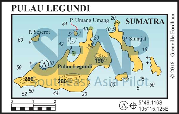
Anchor in 10-14 metres off the fringing reef on the northwest bay of Pulau Legundi. Around the headland, east, is the island village where limited supplies can be found. Anchor on sand at 5°47.983S, 105°17.635E and use the jetty, not the beach as it dries a long way out.
There are plenty of options around this group depending on the prevailing conditions. Just northeast is Pulau Umang Umang, with an all-tide beach with reasonable holding on sand in 4-8 metres, off the beach at 5°47.508S, 105°16.862E.
20 miles south is the famous Krakatoa group at 6°06.040S, 105°26.029E. It used to be possible to anchor off the Anak Krakatoa’s Ranger Station and hike up to the live volcano crater. However, since the catastrophic eruption in December 2018, the island is (at the time of writing) out of bounds because of the unpredictable and continuous volcanic activity.
Heading east, the last available shelter is either side of Pulau Sangiang, athwart the best line through the straits. On the west coast protection can be found two hundred metres off the beach in 8 metres at 5°57.560S, 105°50.881E. On the east coast shelter is best between the fringing reef off the research jetty in 5-7 metres at 5°57.832S, 105°51.990E. There is plenty of ferry traffic between Merak on Java and Lampung on Sumatra. Keep a good watch.


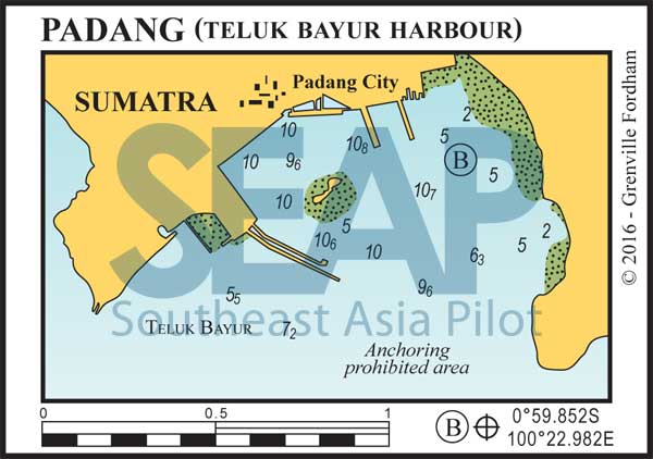
Padang is the capital and largest city of West Sumatra. It is the transit point for surfers travelling to the Batu and Mentawai Islands, as well as tourists visiting the West Samundra highlands.
Teluk Bayur Harbour is the busiest on this coast with plenty of activity along the docks. Anchor in 2-7 metres off the beach opposite the main docks and amongst the local fishing fleet and liveaboard surfing boats.
Better shelter for shoal draft vessels is found 5 miles north, up the small creek used by local surfing charter boats at 0°57.945S, 100°21.116E. It’s a shallow and narrow 70-metre wide creek entrance, but once inside depth levels at 2.5 metres all the way to the bridge.
The CBD is one kilometre north from here and the ferry terminal north of the main anchorage has all the government departments for checking into or out of Indonesia.
The Mentawais, a chain of lush, tropical islands with the most consistent surf breaks on the planet lie 100 miles west of Padang. There are approximately 70 islands and atolls spread out in a northwest-southeast direction for nearly 200 miles.
Siberut is the largest island and lies just across the Mentawai Strait from Padang, the usual launching point for charter boats heading into this surfing paradise.
There are dozens of famous surf breaks where you can drop a day anchor and surf right from your boat, and then duck back to the coast to anchor in one of the shallow hideout holes and creeks.
270 miles from Langkawi


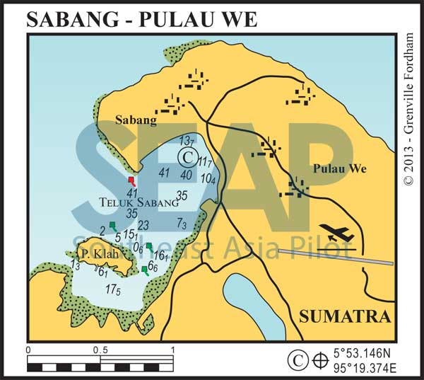
Sabang Harbour on Pulau We is the northernmost point of the Indonesian archipelago and, as such, offers full check-in facilities for visiting yachts.
Anchor in 22-25 metres just north of the commercial dock near the old harbour buildings. If it blows in, better shelter is behind the small island Pulau Klah on the 6-metre patch, just south of the private jetty at 5°52.426N, 95°18.519E. Don’t go out to the west without local knowledge as the bank shallows to under 1 metre.
Only 210 miles from Phuket and 270 from Langkawi, Sabang is close enough to be an attractive entry point, especially for surfing enthusiasts heading for Nias and beyond. The town has all the usual supplies, with fuel available at the concrete jetty to the right of the anchorage. The airport on the island takes domestic flights and the international connections are made from Bandah Aceh on the mainland.
350 miles from Singapore


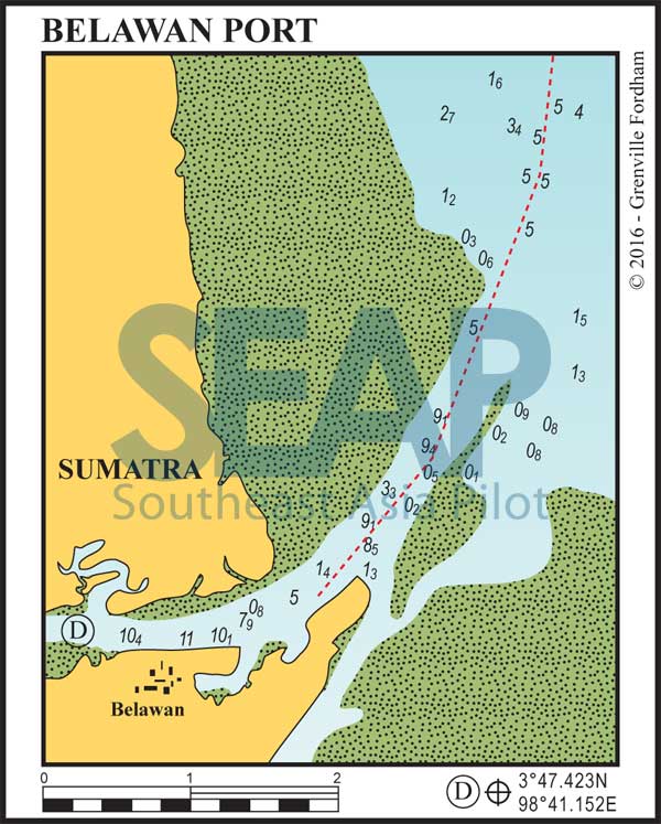
Belawan is a bustling port city and an international point of entry into Indonesia, located on the Deli River on the Malacca Straits coast just north of thriving capital Medan. Belawan is Indonesia’s busiest port outside of Java so the shipping traffic in the approach channel can be hectic. Best plan to arrive in daylight.
Motor to the green can at 3°52.994N, 98°44.632E, then follow the three-mile, well-marked channel into the river and down to the anchorage in 5-10 metres, adjacent to the docks and opposite the Nunang Creek mouth.
Checking in and out of Indonesia here is relatively painless due to the daily crossings to Malaysia and Singapore by ferry. All the government offices are in the same building at the main ferry terminal.
The city of Medan and airport are 30 kilometres south and a ‘bemo’ will take about 40 minutes.
Medan is the main entry point for backpacker tourists visiting the famed massive mountain-top Lake Toba, set in the core of an inactive super-volcano which last erupted 70,000 years ago.
Regular ferry services that connected Medan to Penang and Lumut in Malaysia, and Satun in Thailand, have become more sporadic since the recent launching of several low cost airlines into the area.
