This website uses cookies to improve your experience. We believe you'll be OK with this, but you can opt-out if you wish. Or you can go to 'cookie settings' and choose which cookies to allow. Privacy policy
160 miles from Luganville


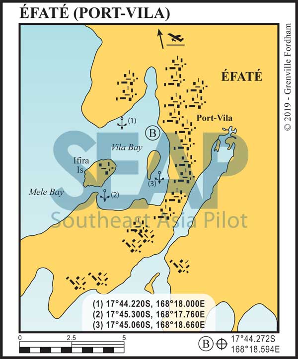
The capital city of Vanuatu is Port Vila. A popular port with several good anchorages and excellent provisioning. A wide, clearly marked, channel and range marks the harbour entrance.
Port-Vila is one of two ports in Vanuatu where you can clear in and out and be issued a cruising permit. There are several agents that can help you with this for a reasonable fee; they can be found online.

If you have the time and patience the Nivan officials are very pleasant to deal with. Just be aware that island time is the norm and being rude will get you nowhere slowly! If you do decide to clear in yourself, have printed copies of all email correspondence with customs and immigration. Especially your 48-hour notice of arrival. For vessels without email capabilities the officials are usually understanding if 48 hours turns out to be 72, as long as you have a copy of your original email.
The main anchorage for vessels under 50m is right next to a quarantine buoy and has good holding in 11m metres. There is a small tender dock operated by the dive shop directly onshore. Anchorage (1) is better for larger vessels; anchor in 20-30 metres. In a strong westerly, anchorages (2) and (3) offer better protection. At anchorage (2) the bottom comes up quickly; anchor in 18 metres and never use it in a strong easterly.
The main wharf is in the southern part of the bay just before the channel entrance to Paray Bay. This is where customs are and where you’ll be issued a cruising permit. For large yachts this is the best place to take on fuel and water. Space is limited and reserved for ships, so book in advance.
There are several other docks in the harbour in various states of use. Always inspect the dock with your tender or confirm with the dock’s owner if it’s usable.
Anchorage (3) is in Paray Bay and is 40m+ deep; However moorings are available. For a mooring, hail on channel 16. If no one answers just grab one; they will eventually find you. The best way to enter the bay is from the south. Sail directly towards the main wharf; the clearly marked channel will be to the east. STAY in the channel which is dredged to 15m.
On the northern side of Éfaté, Havana Bay was used as an anchorage for the US navy during WWII. There are three recommended anchorages here: 17°32.940S, 168°16.920E | 17°33.840S, 168°16.380E | 17°36.240S, 168°14.580E.
If you dive in Havana Bay, you’ll most likely find Coca Cola bottles tossed overboard by US sailors. The entrance of the bay is long and deep with good water right up to the beach. In all three anchorages, anchor in 10 metres. Good holding in mud. There’s a great restaurant and small resorts on both sides of the bay.
